

Limited time offer and only while supplies last. Discount based on original price, and intermediate markdowns may have been taken.
Product Details
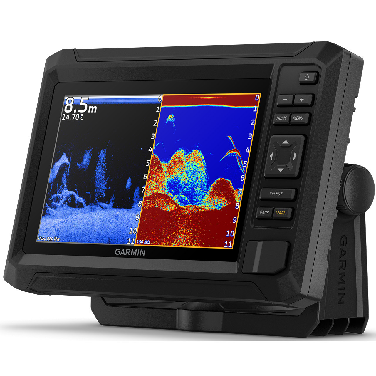
The Garmin ECHOMAP UHD2 74cv Navionics+ U.S. Coastal & Great Lakes chartplotter, paired with the GT20-TM Transducer, provides anglers with the clarity, mapping detail, and connectivity needed to locate and return to productive fishing areas. The bright 7-inch keyed-assist display delivers sharp, high-contrast sonar views using Garmin's traditional sonar and ClearVü scanning sonar, revealing crisp fish arches and structure in vivid color palettes. With preloaded Garmin Navionics+ U.S. Coastal and Great Lakes mapping, anglers can confidently locate depth contours, navigation channels, and potential fishing spots without guesswork.
A 1-year subscription for daily map updates ensures your data stays current, while built-in Wi-Fi allows sharing of sonar, waypoints, and routes between compatible ECHOMAP UHD2 units. Paired with the free ActiveCaptain mobile app, anglers can access OneChart integration, software updates, Garmin Quickdraw Community data, and smart notifications directly from a smartphone. Complete with a GT20-TM Transducer, the Garmin ECHOMAP UHD2 74cv delivers the clarity, coverage, and features serious anglers rely on for both inland and coastal fishing.
- Garmin Part Number: 010-02595-51
- 7 in. keyed display
- Double the views with Garmin CHIRP traditional and ClearVü scanning sonars
- High-contrast vivid color palettes
- WiFi connectivity between compatible chartplotters makes it easy to share info
- Mapping with Garmin Navionics+ inland and coastal content
- Includes:
- ECHOMAP UHD2
- GT20-TM transducer
- Power/data cable
- Tilt mount
- Flush mount
- Hardware
- Documentation
- Technical Specifications:
- Dimensions: 9.1 x 5.6 x 2.6 in.
- Input: Yes
- Display Size: 6.1 x 3.4 in.
- Display Resolution: 800 x 480 pixels
- Display Type: WVGA, TN
- Weight: 1.5 lbs.
- Waterproof Rating: IPX7
- Mounting Options: Bail or flush
- Maps & Memory:
- Accepts Data Cards: 1 microSD card - 32 GB maximum size
- Waypoints: 5,000
- Track Points: 50,000
- Tracks: 50 saved tracks
- Navigation Routes: 100
- Sensors:
- Built-in Receiver: 5 Hz
- GPS and supports WAAS: Yes
- Built-in maps:
- Garmin Navionics+ Inland and Coastal: Yes
- Tide Tables: Yes
- Chartplotter Features:
- ActiveCaptain Compatible; Yes
- Sonar Features & Specifications:
- Sonar Display: Yes
- Power Output: 500 W
- Traditional Sonar (Dual Frequency Beam): built-in (single channel CHIRP, 50/77/83/200 kHz, L, M, H CHIRP)
- ClearVu: built-in 260/455/800/1000/1200 kHz
- Connections:
- 4-pin Transducer Ports: 1
- Garmin Wi-Fi Network (local connection): Yes
- Electrical Features:
- Power Input: 9 to 18 Vdc
- Typical Current Draw at 12 Vdc: 1.0 A
- Maximum Current Draw at 12 Vdc: 1.5 A
- Maximum Power Usage at 10 Vdc: 18W