


Limited time offer and only while supplies last. Discount based on original price, and intermediate markdowns may have been taken.

FINS Windtamer Braid


$19.99 - $404.99


FINS Windtamer Braid

FINS Crappie Braid


FINS 40G Composite Superline Braid


FINS Spin5 Fishing Braid


FINS XS Big Game Braid


FINS Infinity Braid

Sufix 832 Advanced Superline


Sufix Revolve Braided Line


Sufix Elite Premium Monofilament Line


Sufix Advance Monofilament Line


Sufix Performance Lead Core Line


Sufix ProMix Braided Line


Sufix 832 Advanced Lead Core Line


Seaguar Blue Label Fluorocarbon Leader...


Daiwa Presso Ultralight Spinning Rod
10 Model Options

Daiwa Spinmatic D Spinning Rod
9 Model Options

Seaguar InvizX Fluorocarbon Line

Daiwa Wilderness Trolling Rod
8 Model Options

Lew's Lite Spinning Rod
8 Model Options

Lew's Wally Marshall Speed Shooter...
2 Model Options
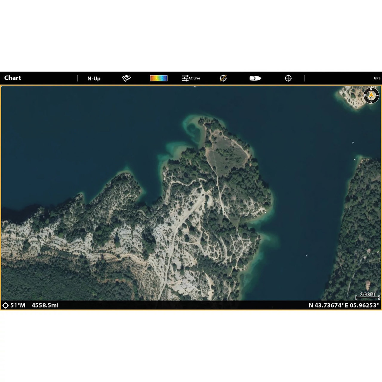
Humminbird LakeMaster Premium Digital Maps give an added advantage over standard LakeMaster Maps, supplying you with additional features, 2D Shaded Relief, and Aerial Imagery! The 2D Shaded Relief makes bottom detail and depth changes even easier to spot. Aerial Imagery helps you ID new honey holes and navigate to other points of interest. VX Technology is standard and features more than 13,000 lake maps in 13 regions in North America. Updated LakeMaster Maps SD Cards offer enhanced underwater mapping, detailed shorelines, and adjustable color schemes to help you rapidly uncover the best fishing spots you can find anywhere. SmartStrike is a digital fishing assistant that helps you anticipate where the fish will be. Integrated into the LakeMaster map cards, SmartStrike allows you to input search specifications such as season, time of day, temperature, and type of fish. Mark the spots on the map where fish are most likely to bite!
Using the LakeMaster Digital Map, switching between custom view settings is easy and straightforward. You can define up to four adjustable depths to locate the most abundant fishing grounds. The cartography also features a red shade to illustrate shallow water zones with a range of 0 to 60 feet. Additionally, the depth contours are designed to match the current water levels of lakes, rivers, and reservoirs. You can get the most out of your Humminbird LakeMaster maps by connecting a Humminbird fish finder and a compatible Minn Kota trolling motor to the One-Boat Network. For hands-free fishing, your Minn Kota can automatically follow a depth contour on your LakeMaster chart! To get an accurate map of the waters you fish, put a digital Humminbird LakeMaster Premium Map at your fingertips!

Yo-Zuri SuperBraid Five Color Braided...

Berkley Trilene Big Game Braid


Mad Katz Kat Braid


PowerPro Braided Spectra Fiber Line


PowerPro Super 8 Slick V2 Microfilament...


Cortland Master Braid Line


Seaguar Smackdown Braid


Berkley FireLine Thermally Fused...


K9 Crappie Braid


Berkley Forward Braid


P-Line EndurX No Fade Braid


Sufix 131 G-Core Braided Line


Keitech Easy Shiner
80 Color Options

Bandit Walleye Deep Diver
145 Color Options

Moonshine Lures Trolling Spoon
90 Color Options

Keitech Fat Swing Impact
87 Color Options

VMC Neon Moon Eye Jigs
27 Color Options

Yakima Bait Mag Lip
97 Color Options

ACME Tackle Kastmaster
45 Color Options

Brad's ThinFish
28 Color Options


